Home | NAV-3000
NAV-3000 Integrated Navigation System
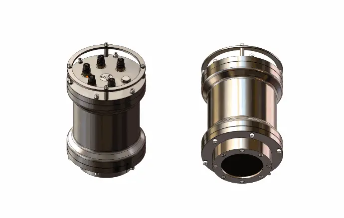
Underwater INS/DVL/Pressure Sensor
The NAV-3000 Integrated Navigation System is primarily composed of three core underwater sensing units: an Underwater Inertial Navigation System (INS), an Underwater Doppler Velocity Log (DVL), and an Underwater Pressure Sensor. It achieves high-precision positioning, attitude calculation, and depth monitoring for underwater vehicles through multi-source data fusion algorithms.
NAV-3000
Key Features:
- Compact size, high accuracy, autonomous north-seeking, immune to magnetic interference.
- Straight-line navigation accuracy: ≤0.5% of distance; Z-shaped survey pattern accuracy: ≤0.1%.
- Integrated high-resolution pressure sensor, 3000 m depth-rated version with 1.5 cm resolution.
- Phased array DVL, navigation accuracy unaffected by sound speed variations.
- Automatically switches to water-track mode when bottom-track is lost in deep water.
- Supports USBL position aiding with automatic outlier rejection.
- Built-in Wi-Fi module for configuration and data access.
Overview
Performance
NAV-3000 is a new-generation integrated navigation system, designed for high-precision AUV / ROV underwater navigation.
- Autonomous north-seeking: achieves self-alignment by sensing the Earth’s rotational angular velocity, without relying on magnetic fields.
- Pressure-resistant design: titanium-alloy housing allows direct underwater deployment without modifications.
- Core sensors: integrates a phased-array DVL and a high-resolution pressure sensor.
-
Combined positioning: supports DVL, GPS, and USBL integration, outputting attitude, position, velocity, and depth data.
- Navigation accuracy: with DVL integration, achieves 0.5% of distance traveled in straight-line navigation and 0.1% of distance traveled during area mapping.
- Depth measurement: pressure sensor resolution 0.0005% of full scale, accuracy 0.05% of full scale.
- IMU and data fusion: enhances attitude and heading accuracy, ensuring stable underwater navigation.
Specifications
Applications
- Deep-sea research, mapping, and sampling
- Pipeline and cable inspection, subsea infrastructure monitoring
- AUV/ROV autonomous navigation missions
- Regional ocean environmental monitoring
Navigation Mode
SINS / DVL / GPS / Depth Sensor Integrated Navigation Mode
This is the default operating mode of the system.
Features:
- When GPS velocity is valid, SINS integrates with GPS.
- When GPS is invalid, SINS integrates with depth sensor and DVL. If both water-track and bottom-track are valid, bottom-track velocity is used. In deep water, if only water-track is available, SINS integrates with water-track velocity.
- If both DVL and GPS are invalid, the system enters vertical gyro mode: velocity is zeroed, but accurate attitude is maintained.
- When valid USBL position is received, outliers are automatically rejected and navigation error is corrected.
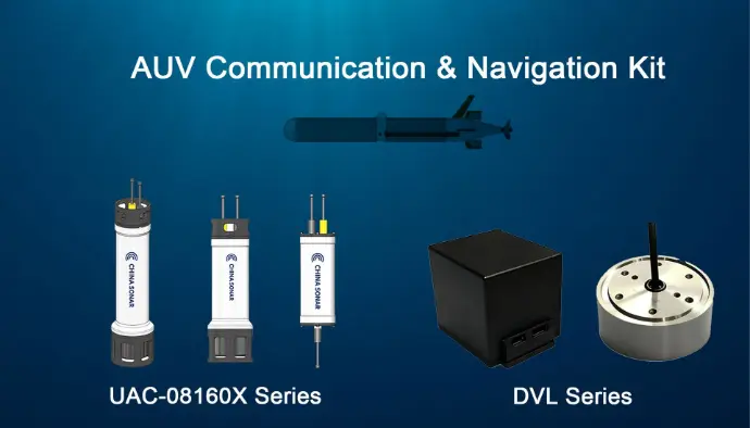
AUV Communication & Navigation Kit
DVL-600K / DVL-300K & UAC-08160X Series
To meet the demanding requirements of Autonomous Underwater Vehicles (AUVs) for high-precision navigation and reliable communication, we offer the AUV Communication & Navigation Kit. This solution integrates the Doppler Velocity Log (DVL) with the Underwater Acoustic Communication (UAC) system, providing a comprehensive package for scientific research, underwater inspection, and long-range operations.