Home | Wave Glider Series | Wave Glider USV3
USV3 Wave Glider
Solar-Powered Uncrewed Surface Vehicle (USV)
The USV3 Wave Glider harnesses wave energy and solar energy for forward propulsion, enabling endurance of up to several months. The system is man-portable and can be launched directly from beaches, ramps, or docks, providing persistent maritime domain awareness for border regions, ports, and offshore infrastructure.
The platform is capable of successful operation in Sea State 6 and above, and is equipped with redundant communication systems to ensure global-scale reliability. Featuring a modular open system architecture (MOSA), the USV3 supports rapid hardware and software integration.
Collected observation and sensing data are transmitted back to shore-based monitoring centers in the form of processed computational results, marking a new stage in the development of unmanned ocean observation and sensing systems.
Overview
Wave Glider USV3
Key Features:
- Hybrid Propulsion
- High Payload Capacity
- All-Weather, Long-Endurance Operation
- Full Sea-State Capability
- Cross-Medium Real-Time Data Relay
- Cost-Effective, Efficient Platform
- Distributed Area Coverage
- Secure Real-Time Data Link
- Green Energy Powered
- Supports Acoustic, Optical, Electrical, and Magnetic Sensors
- Silent & Low-Observable Operation
Standard Configuration
Scientific Payloads
The Wave Glider can be equipped with a wide range of scientific payloads, including meteorological stations, laser Doppler wind lidar, atmospheric duct sensors, wave sensors, CTD (Conductivity–Temperature–Depth) sensors, temperature and salinity winches, ADCP (Acoustic Doppler Current Profilers), multi-parameter water quality sensors, hydrophones, magnetometers, vision-based recognition systems, and AIS receivers.
These payloads enable missions such as marine meteorological observation, tsunami and earthquake monitoring, marine mammal and biological monitoring, and offshore energy exploration. In addition, the Wave Glider can carry underwater acoustic communication modems to perform surface-to-underwater data relay and communication gateway missions.
Unique Capabilities
The Wave Glider features self-sustaining energy supply, global positioning, satellite communications, and autonomous navigation. It is capable of autonomous navigation along predefined routes or virtual anchoring around designated locations, enabling long-duration, wide-area unmanned continuous survey operations (up to 10,000 km per year).
In addition, the platform supports virtual station-keeping at fixed sea-surface locations, providing data relay and communication gateway services for underwater and surface-based systems, as well as long-range real-time data transmission to shore-based control centers.
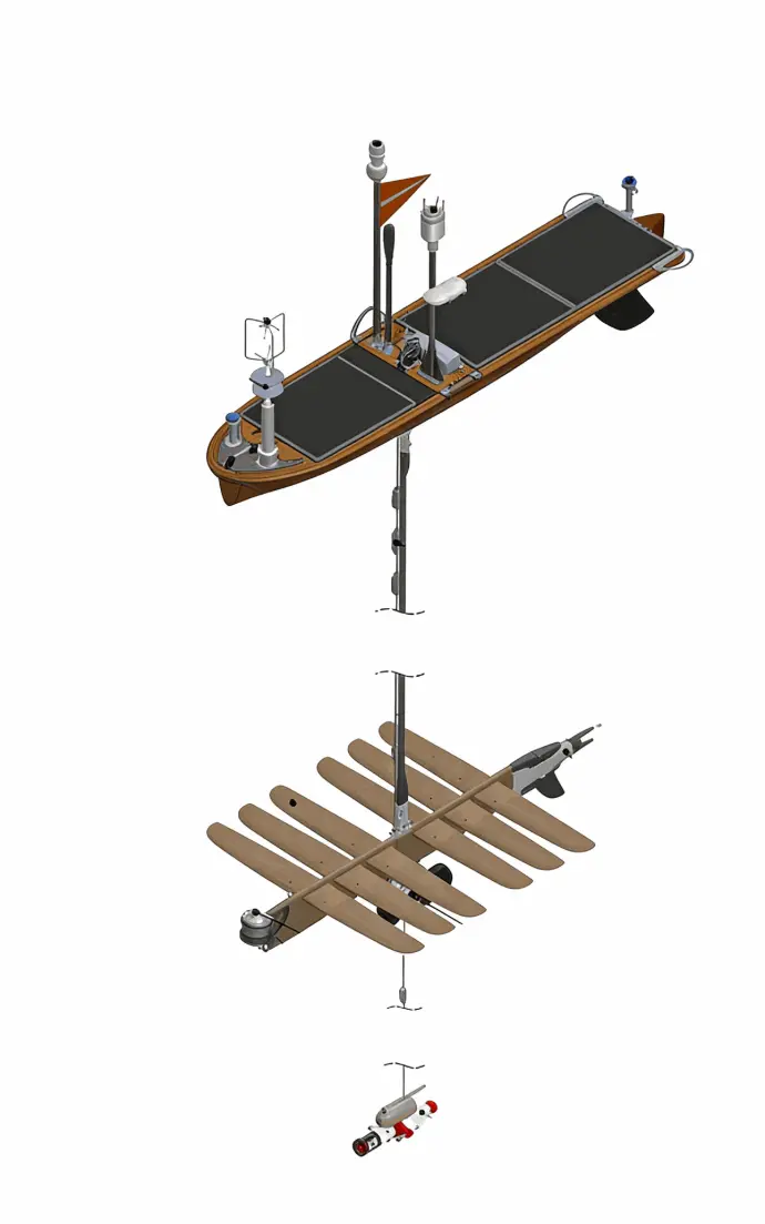
Product Schematic

Applications
- Marine Meteorological Observation
Continuous measurement of wind speed, wind direction, air temperature, atmospheric pressure, and humidity, supporting offshore weather monitoring, forecasting, and climate research.
- Sea Surface and Upper-Ocean Hydrological Observation
Real-time observation of wave height, wave direction, current speed, current direction, sea surface temperature, and salinity, enabling long-term monitoring of ocean surface dynamics and air–sea interactions.
- Coastal Security and Maritime Patrol
Persistent coastal and nearshore surveillance using video, optical imagery, and radar data, supporting maritime domain awareness and coastal security operations.
- Underwater Acoustic Measurement
Measurement of ambient underwater noise and direction finding and localization of underwater targets, supporting ocean acoustic research and maritime safety applications.
- Ocean Dynamics and Profiling Observation
Acquisition of vertical profiles of current velocity and direction, as well as water temperature and salinity profiles, enabling studies of ocean circulation and water column structure.
- Marine Water Quality and Ecosystem Monitoring
Long-term monitoring of pH, dissolved oxygen, turbidity, chlorophyll, partial pressure of carbon dioxide (pCO₂), radioactivity, and other key indicators, supporting marine environmental protection and ecosystem assessment.